Download as PDF, PPTX


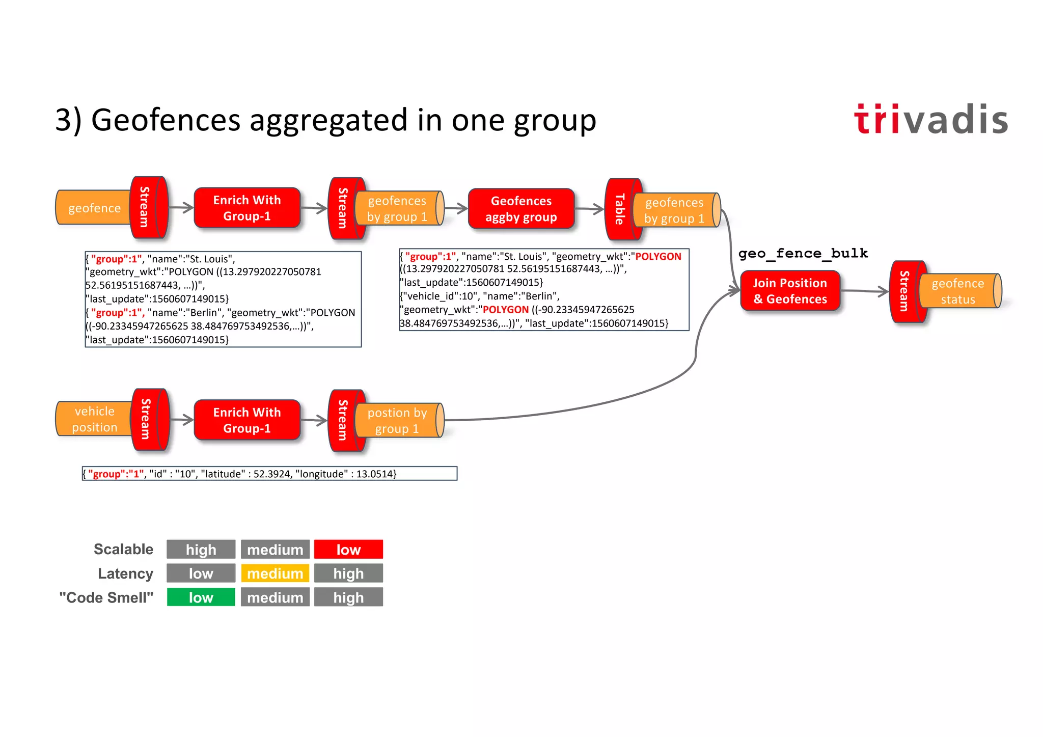
![3) Geofences aggregated in one group
• CREATE STREAM a03_geo_fence_status_s
• AS
• SELECT vehp.id, vehp.latitude, vehp.longitude,
geo_fence_bulk(vehp.latitude, vehp.longitude,
geofaggid_geometry_wkt_list) AS geofence_status
• FROM a03_vehicle_position_by_group_s vehp
• LEFT JOIN a03_geo_fence_aggby_group_t geofagg
• ON vehp.group_id = geofagg.group_id;
ksql> SELECT * FROM a03_geo_fence_status_s;
46 | 52.47546 | 13.34851 | [1:OUTSIDE, 3:INSIDE]
46 | 52.47521 | 13.34881 | [1:OUTSIDE, 3:INSIDE]
...
As many as there are geo-fences](https://image.slidesharecdn.com/geo-analytics-with-kafka-v1-190925093725/75/Location-Analytics-Real-Time-Geofencing-using-Kafka-19-2048.jpg)
![Geo Hash Custom UDF
ksql> SELECT latitude, longitude, geo_hash(latitude, longitude, 3)
>FROM test_geo_udf_s;
38.484769753492536 | -90.23345947265625 | 9yz
public String geohash(final double latitude,
final double longitude, int length)
public List<String> neighbours(String geohash)
public String adjacentHash(String geohash, String directionString)
public List<String> coverBoundingBox(String geometryWKT, int length)
ksql> SELECT geometry_wkt, geo_hash(geometry_wkt, 5)
>FROM test_geo_udf_s;
POLYGON ((-90.23345947265625 38.484769753492536, -90.25886535644531
38.47455675836861, ...)) | [9yzf6, 9yzf7, 9yzfd, 9yzfe, 9yzff, 9yzfg, 9yzfk,
9yzfs, 9yzfu]](https://image.slidesharecdn.com/geo-analytics-with-kafka-v1-190925093725/75/Location-Analytics-Real-Time-Geofencing-using-Kafka-21-2048.jpg)
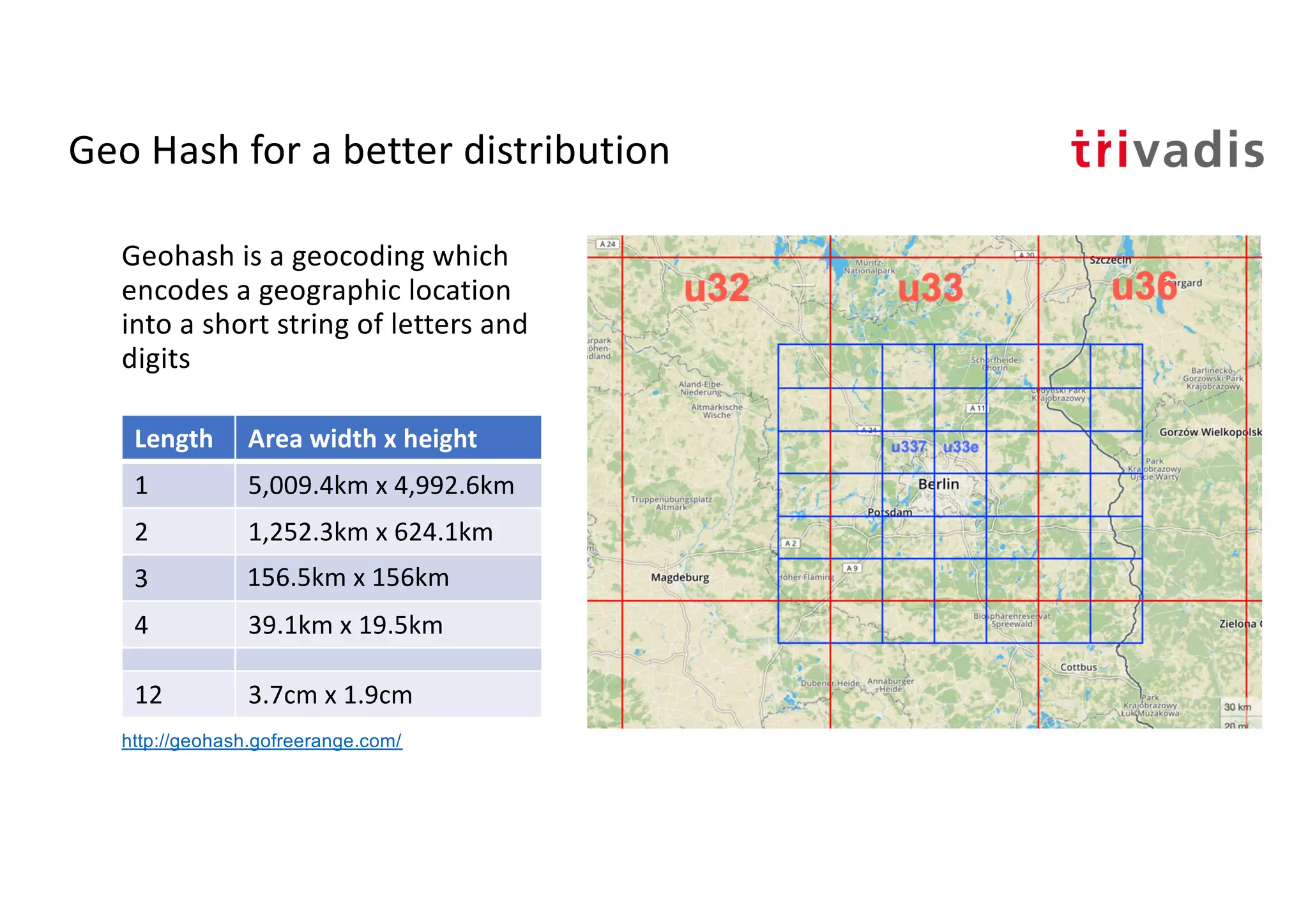
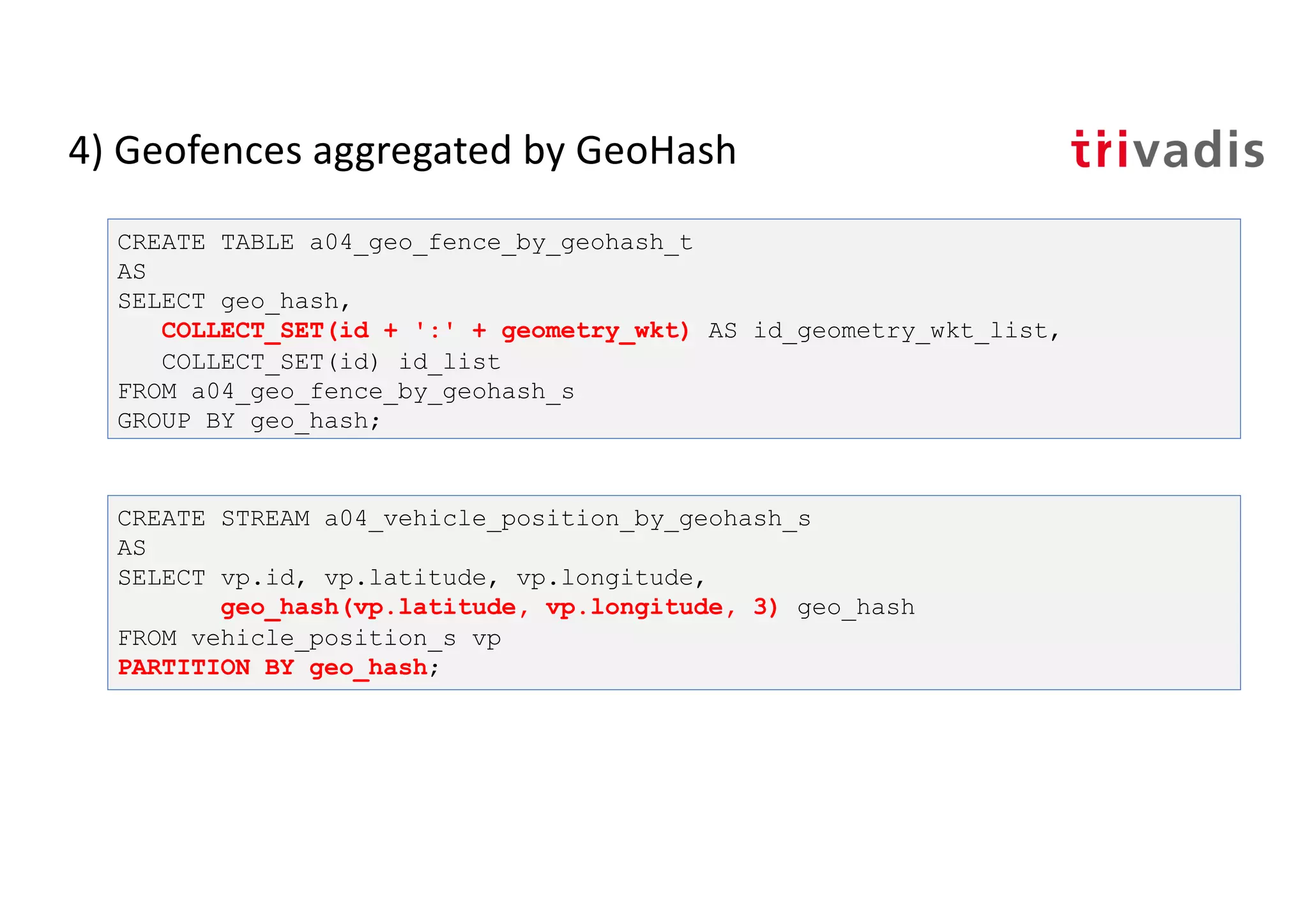
![4) Geofences aggregated by GeoHash
CREATE STREAM a04_geo_fence_by_geohash_s
AS
SELECT geo_hash(geometry_wkt, 3)[0] geo_hash, id, name, geometry_wkt
FROM a04_geo_fence_s
PARTITION by geo_hash;
INSERT INTO a04_geo_fence_by_geohash_s
SELECT geo_hash(geometry_wkt, 3)[1] geo_hash, id, name, geometry_wkt
FROM a04_geo_fence_s
WHERE geo_hash(geometry_wkt, 3)[1] IS NOT NULL
PARTITION BY geo_hash;s
INSERT INTO a04_geo_fence_by_geohash_s
SELECT ...
There is no explode()
functionality in KSQL! https://github.com/confluentinc/ksql/issues/527](https://image.slidesharecdn.com/geo-analytics-with-kafka-v1-190925093725/75/Location-Analytics-Real-Time-Geofencing-using-Kafka-23-2048.jpg)
![4) Geofences aggregated by GeoHash
CREATE STREAM a04_geo_fence_status_s
AS
SELECT vp.geo_hash, vp.id, vp.latitude, vp.longitude,
geo_fence_bulk (vp.latitude, vp.longitude, gf.id_geometry_wkt_list)
AS fence_status
FROM a04_vehicle_position_by_geohash_s vp
LEFT JOIN a04_geo_fence_by_geohash_t gf
ON (vp.geo_hash = gf.geo_hash);
ksql> SELECT * FROM a04_geo_fence_status_s;
u33 | 46 | 52.3906 | 13.1599 | [3:OUTSIDE]
u33 | 46 | 52.3906 | 13.1599 | [3:OUTSIDE]
9yz | 12 | 38.34409 | -90.15034 | [2:OUTSIDE, 1:OUTSIDE]
...
As many as there are geo-fences in
geohash](https://image.slidesharecdn.com/geo-analytics-with-kafka-v1-190925093725/75/Location-Analytics-Real-Time-Geofencing-using-Kafka-25-2048.jpg)
![4b) Geofences aggregated by GeoHash
CREATE STREAM a04b_geofence_udf_status_s
AS
SELECT id, latitude, longitude, id_list[0] AS geofence_id,
geo_fence(latitude, longitude, geometry_wkt_list[0]) AS geofence_status
FROM a04_vehicle_position_by_geohash_s vp
LEFT JOIN a04_geo_fence_by_geohash_t gf
ON (vp.geo_hash = gf.geo_hash);
INSERT INTO a04b_geofence_udf_status_s
SELECT id, latitude, longitude, id_list[1] geofence_id,
geo_fence(latitude, longitude, geometry_wkt_list[1]) AS geofence_status
FROM a04_vehicle_position_by_geohash_s vp
LEFT JOIN a04_geo_fence_by_geohash_t gf
ON (vp.geo_hash = gf.geo_hash)
WHERE id_list[1] IS NOT NULL;](https://image.slidesharecdn.com/geo-analytics-with-kafka-v1-190925093725/75/Location-Analytics-Real-Time-Geofencing-using-Kafka-28-2048.jpg)
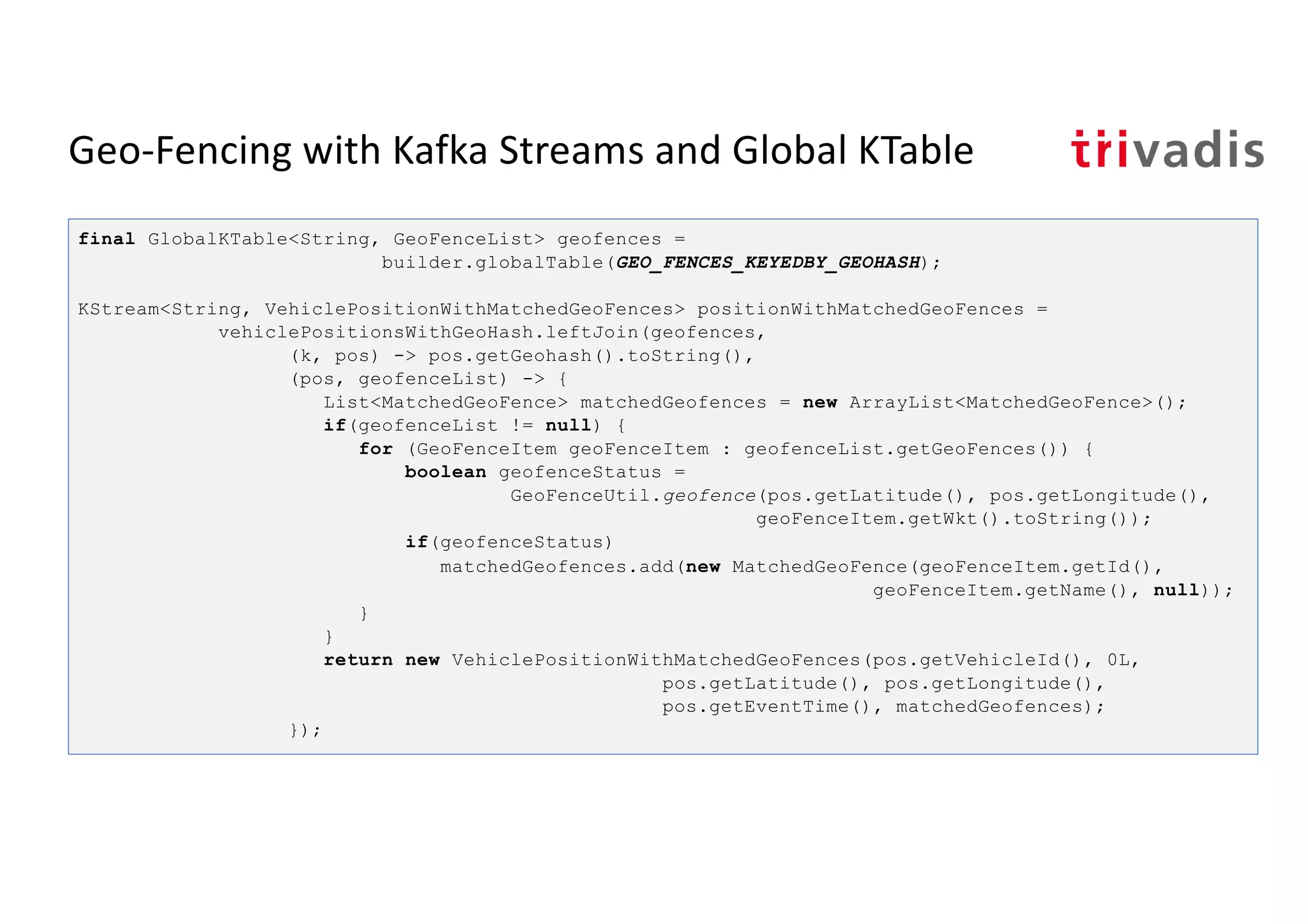
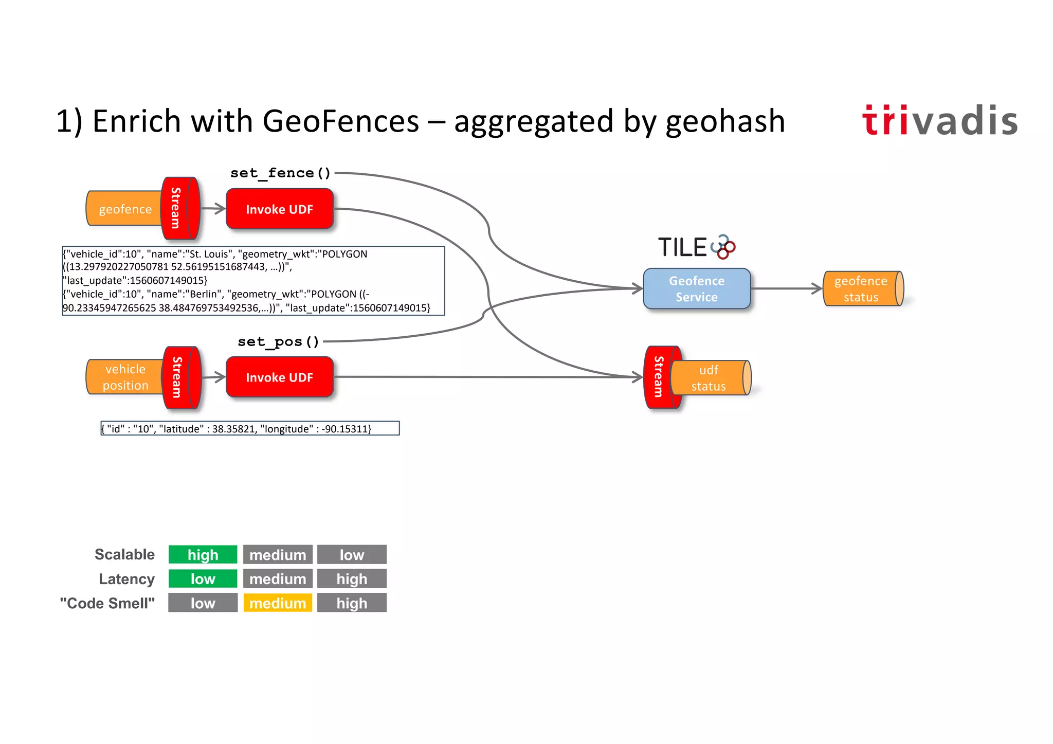
![Geo-Fencing with Kafka Streams and Global KTable
Enrich Position with GeoHash
& Join with Geofences
Global
KTable
{ "geohash":u33", "name":"Potsdam",
"geometry_wkt":"POLYGON ((5.668945
51.416016, …))",
"last_update":1560607149015}
{"vehicle_id":10", "name":"Berlin",
"geometry_wkt":"POLYGON ((-
90.23345947265625
38.484769753492536,…))",
"last_update":1560607149015}
geofence
KTable
vehicle
position
{ "geohash":u33", "name":"Potsdam",
"geometry_wkt":"POLYGON ((5.668945
51.416016, …))",
"last_update":1560607149015}
{ "group":u33", "name":"Berlin",
"geometry_wkt":"POLYGON ((-
90.23345947265625
38.484769753492536,…))",
"last_update":1560607149015}
Enricht and Group
by GeoHash
matched
geofences
Detect Geo
Event
geofece_sa
tus
high low
low high
low high
Scalable
Latency
"Code Smell"
medium
medium
medium
geofence
by geohash
{"id":"10", "latitude" : 52.3924,
"longitude" : 13.0514, [
{"name":"Berlin"} ] }
{ "geohash":"u33", "id" : "10", "latitude" : 52.3924, "longitude" : 13.0514}
{"id":"10", "status" : "ENTER", "geofenceName":"Berlin"} }
position &
geohash](https://image.slidesharecdn.com/geo-analytics-with-kafka-v1-190925093725/75/Location-Analytics-Real-Time-Geofencing-using-Kafka-31-2048.jpg)
![Geo-Fencing with Kafka Streams and Global KTable
KStream<String, GeoFence> geoFence = builder.stream(GEO_FENCE);
KStream<String, GeoFence> geoFenceByGeoHash =
geoFence.map((k,v) -> KeyValue.<GeoFence, List<String>> pair(v,
GeoHashUtil.coverBoundingBox(v.getWkt().toString(), 5)))
.flatMapValues(v -> v)
.map((k,v) -> KeyValue.<String,GeoFence>pair(v, createFrom(k, v)));
KTable<String, GeoFenceList> geofencesByGeohash =
geoFenceByGeoHash.groupByKey().aggregate(
() -> new GeoFenceList(new ArrayList<GeoFenceItem>()),
(aggKey, newValue, aggValue) -> {
GeoFenceItem geoFenceItem = new
GeoFenceItem(newValue.getId(), newValue.getName(),
newValue.getWkt(), "");
if (!aggValue.getGeoFences().contains(geoFenceItem))
aggValue.getGeoFences().add(geoFenceItem);
return aggValue;
},
Materialized.<String, GeoFenceList,
KeyValueStore<Bytes,byte[]>>as("geofences-by-geohash-store"));
geofencesByGeohash.toStream().to(GEO_FENCES_KEYEDBY_GEOHASH,
Produced.<String, GeoFenceList> keySerde(stringSerde));](https://image.slidesharecdn.com/geo-analytics-with-kafka-v1-190925093725/75/Location-Analytics-Real-Time-Geofencing-using-Kafka-32-2048.jpg)

![Tile38 – How does it work?
> SETCHAN berlin WITHIN vehicle FENCE OBJECT
{"type":"Polygon","coordinates":[[[13.297920227050781,52.56195151687443],[1
3.2440185546875,52.530216577830124],[13.267364501953125,52.45998421679598],
[13.35113525390625,52.44826791583386],[13.405036926269531,52.44952338289473
],[13.501167297363281,52.47148826410652], ...]]}
> SUBSCRIBE berlin
{"ok":true,"command":"subscribe","channel":"berlin","num":1,"elapsed":"5.85
µs"}
.
.
.
{"command":"set","group":"5d07581689807d000193ac33","detect":"outside","hoo
k":"berlin","key":"vehicle","time":"2019-06-
17T09:06:30.624923584Z","id":"10","object":{"type":"Point","coordinates":[1
3.3096,52.4497]}}
SET vehicle 10 POINT 52.4497 13.3096](https://image.slidesharecdn.com/geo-analytics-with-kafka-v1-190925093725/75/Location-Analytics-Real-Time-Geofencing-using-Kafka-37-2048.jpg)
![Tile38 – How does it work?
> SETHOOK berlin_hook kafka://broker-1:9092/tile38_geofence_status WITHIN
vehicle FENCE OBJECT
{"type":"Polygon","coordinates":[[[13.297920227050781,52.56195151687443],[1
3.2440185546875,52.530216577830124],[13.267364501953125,52.45998421679598],
[13.35113525390625,52.44826791583386],[13.405036926269531,52.44952338289473
],[13.501167297363281,52.47148826410652], ...]]}
bigdata@bigdata:~$ kafkacat -b localhost -t tile38_geofence_status
% Auto-selecting Consumer mode (use -P or -C to override)
{"command":"set","group":"5d07581689807d000193ac34","detect":"outside","hoo
k":"berlin_hook","key":"vehicle","time":"2019-06-
17T09:12:00.488599119Z","id":"10","object":{"type":"Point","coordinates":[1
3.3096,52.4497]}}
SET vehicle 10 POINT 52.4497 13.3096](https://image.slidesharecdn.com/geo-analytics-with-kafka-v1-190925093725/75/Location-Analytics-Real-Time-Geofencing-using-Kafka-38-2048.jpg)


![3) Geofences aggregated in one group
• CREATE STREAM a03_geo_fence_status_s
• AS
• SELECT vehp.id, vehp.latitude, vehp.longitude,
geo_fence_bulk(vehp.latitude, vehp.longitude,
geofaggid_geometry_wkt_list) AS geofence_status
• FROM a03_vehicle_position_by_group_s vehp
• LEFT JOIN a03_geo_fence_aggby_group_t geofagg
• ON vehp.group_id = geofagg.group_id;
ksql> SELECT * FROM a03_geo_fence_status_s;
46 | 52.47546 | 13.34851 | [1:OUTSIDE, 3:INSIDE]
46 | 52.47521 | 13.34881 | [1:OUTSIDE, 3:INSIDE]
...
As many as there are geo-fences](https://crownmelresort.com/image.slidesharecdn.com/geo-analytics-with-kafka-v1-190925093725/75/Location-Analytics-Real-Time-Geofencing-using-Kafka-19-2048.jpg)

![Geo Hash Custom UDF
ksql> SELECT latitude, longitude, geo_hash(latitude, longitude, 3)
>FROM test_geo_udf_s;
38.484769753492536 | -90.23345947265625 | 9yz
public String geohash(final double latitude,
final double longitude, int length)
public List<String> neighbours(String geohash)
public String adjacentHash(String geohash, String directionString)
public List<String> coverBoundingBox(String geometryWKT, int length)
ksql> SELECT geometry_wkt, geo_hash(geometry_wkt, 5)
>FROM test_geo_udf_s;
POLYGON ((-90.23345947265625 38.484769753492536, -90.25886535644531
38.47455675836861, ...)) | [9yzf6, 9yzf7, 9yzfd, 9yzfe, 9yzff, 9yzfg, 9yzfk,
9yzfs, 9yzfu]](https://crownmelresort.com/image.slidesharecdn.com/geo-analytics-with-kafka-v1-190925093725/75/Location-Analytics-Real-Time-Geofencing-using-Kafka-21-2048.jpg)

![4) Geofences aggregated by GeoHash
CREATE STREAM a04_geo_fence_by_geohash_s
AS
SELECT geo_hash(geometry_wkt, 3)[0] geo_hash, id, name, geometry_wkt
FROM a04_geo_fence_s
PARTITION by geo_hash;
INSERT INTO a04_geo_fence_by_geohash_s
SELECT geo_hash(geometry_wkt, 3)[1] geo_hash, id, name, geometry_wkt
FROM a04_geo_fence_s
WHERE geo_hash(geometry_wkt, 3)[1] IS NOT NULL
PARTITION BY geo_hash;s
INSERT INTO a04_geo_fence_by_geohash_s
SELECT ...
There is no explode()
functionality in KSQL! https://github.com/confluentinc/ksql/issues/527](https://crownmelresort.com/image.slidesharecdn.com/geo-analytics-with-kafka-v1-190925093725/75/Location-Analytics-Real-Time-Geofencing-using-Kafka-23-2048.jpg)

![4) Geofences aggregated by GeoHash
CREATE STREAM a04_geo_fence_status_s
AS
SELECT vp.geo_hash, vp.id, vp.latitude, vp.longitude,
geo_fence_bulk (vp.latitude, vp.longitude, gf.id_geometry_wkt_list)
AS fence_status
FROM a04_vehicle_position_by_geohash_s vp
LEFT JOIN a04_geo_fence_by_geohash_t gf
ON (vp.geo_hash = gf.geo_hash);
ksql> SELECT * FROM a04_geo_fence_status_s;
u33 | 46 | 52.3906 | 13.1599 | [3:OUTSIDE]
u33 | 46 | 52.3906 | 13.1599 | [3:OUTSIDE]
9yz | 12 | 38.34409 | -90.15034 | [2:OUTSIDE, 1:OUTSIDE]
...
As many as there are geo-fences in
geohash](https://crownmelresort.com/image.slidesharecdn.com/geo-analytics-with-kafka-v1-190925093725/75/Location-Analytics-Real-Time-Geofencing-using-Kafka-25-2048.jpg)


![4b) Geofences aggregated by GeoHash
CREATE STREAM a04b_geofence_udf_status_s
AS
SELECT id, latitude, longitude, id_list[0] AS geofence_id,
geo_fence(latitude, longitude, geometry_wkt_list[0]) AS geofence_status
FROM a04_vehicle_position_by_geohash_s vp
LEFT JOIN a04_geo_fence_by_geohash_t gf
ON (vp.geo_hash = gf.geo_hash);
INSERT INTO a04b_geofence_udf_status_s
SELECT id, latitude, longitude, id_list[1] geofence_id,
geo_fence(latitude, longitude, geometry_wkt_list[1]) AS geofence_status
FROM a04_vehicle_position_by_geohash_s vp
LEFT JOIN a04_geo_fence_by_geohash_t gf
ON (vp.geo_hash = gf.geo_hash)
WHERE id_list[1] IS NOT NULL;](https://crownmelresort.com/image.slidesharecdn.com/geo-analytics-with-kafka-v1-190925093725/75/Location-Analytics-Real-Time-Geofencing-using-Kafka-28-2048.jpg)


![Geo-Fencing with Kafka Streams and Global KTable
Enrich Position with GeoHash
& Join with Geofences
Global
KTable
{ "geohash":u33", "name":"Potsdam",
"geometry_wkt":"POLYGON ((5.668945
51.416016, …))",
"last_update":1560607149015}
{"vehicle_id":10", "name":"Berlin",
"geometry_wkt":"POLYGON ((-
90.23345947265625
38.484769753492536,…))",
"last_update":1560607149015}
geofence
KTable
vehicle
position
{ "geohash":u33", "name":"Potsdam",
"geometry_wkt":"POLYGON ((5.668945
51.416016, …))",
"last_update":1560607149015}
{ "group":u33", "name":"Berlin",
"geometry_wkt":"POLYGON ((-
90.23345947265625
38.484769753492536,…))",
"last_update":1560607149015}
Enricht and Group
by GeoHash
matched
geofences
Detect Geo
Event
geofece_sa
tus
high low
low high
low high
Scalable
Latency
"Code Smell"
medium
medium
medium
geofence
by geohash
{"id":"10", "latitude" : 52.3924,
"longitude" : 13.0514, [
{"name":"Berlin"} ] }
{ "geohash":"u33", "id" : "10", "latitude" : 52.3924, "longitude" : 13.0514}
{"id":"10", "status" : "ENTER", "geofenceName":"Berlin"} }
position &
geohash](https://crownmelresort.com/image.slidesharecdn.com/geo-analytics-with-kafka-v1-190925093725/75/Location-Analytics-Real-Time-Geofencing-using-Kafka-31-2048.jpg)
![Geo-Fencing with Kafka Streams and Global KTable
KStream<String, GeoFence> geoFence = builder.stream(GEO_FENCE);
KStream<String, GeoFence> geoFenceByGeoHash =
geoFence.map((k,v) -> KeyValue.<GeoFence, List<String>> pair(v,
GeoHashUtil.coverBoundingBox(v.getWkt().toString(), 5)))
.flatMapValues(v -> v)
.map((k,v) -> KeyValue.<String,GeoFence>pair(v, createFrom(k, v)));
KTable<String, GeoFenceList> geofencesByGeohash =
geoFenceByGeoHash.groupByKey().aggregate(
() -> new GeoFenceList(new ArrayList<GeoFenceItem>()),
(aggKey, newValue, aggValue) -> {
GeoFenceItem geoFenceItem = new
GeoFenceItem(newValue.getId(), newValue.getName(),
newValue.getWkt(), "");
if (!aggValue.getGeoFences().contains(geoFenceItem))
aggValue.getGeoFences().add(geoFenceItem);
return aggValue;
},
Materialized.<String, GeoFenceList,
KeyValueStore<Bytes,byte[]>>as("geofences-by-geohash-store"));
geofencesByGeohash.toStream().to(GEO_FENCES_KEYEDBY_GEOHASH,
Produced.<String, GeoFenceList> keySerde(stringSerde));](https://crownmelresort.com/image.slidesharecdn.com/geo-analytics-with-kafka-v1-190925093725/75/Location-Analytics-Real-Time-Geofencing-using-Kafka-32-2048.jpg)


![Tile38 – How does it work?
> SETCHAN berlin WITHIN vehicle FENCE OBJECT
{"type":"Polygon","coordinates":[[[13.297920227050781,52.56195151687443],[1
3.2440185546875,52.530216577830124],[13.267364501953125,52.45998421679598],
[13.35113525390625,52.44826791583386],[13.405036926269531,52.44952338289473
],[13.501167297363281,52.47148826410652], ...]]}
> SUBSCRIBE berlin
{"ok":true,"command":"subscribe","channel":"berlin","num":1,"elapsed":"5.85
µs"}
.
.
.
{"command":"set","group":"5d07581689807d000193ac33","detect":"outside","hoo
k":"berlin","key":"vehicle","time":"2019-06-
17T09:06:30.624923584Z","id":"10","object":{"type":"Point","coordinates":[1
3.3096,52.4497]}}
SET vehicle 10 POINT 52.4497 13.3096](https://crownmelresort.com/image.slidesharecdn.com/geo-analytics-with-kafka-v1-190925093725/75/Location-Analytics-Real-Time-Geofencing-using-Kafka-37-2048.jpg)
![Tile38 – How does it work?
> SETHOOK berlin_hook kafka://broker-1:9092/tile38_geofence_status WITHIN
vehicle FENCE OBJECT
{"type":"Polygon","coordinates":[[[13.297920227050781,52.56195151687443],[1
3.2440185546875,52.530216577830124],[13.267364501953125,52.45998421679598],
[13.35113525390625,52.44826791583386],[13.405036926269531,52.44952338289473
],[13.501167297363281,52.47148826410652], ...]]}
bigdata@bigdata:~$ kafkacat -b localhost -t tile38_geofence_status
% Auto-selecting Consumer mode (use -P or -C to override)
{"command":"set","group":"5d07581689807d000193ac34","detect":"outside","hoo
k":"berlin_hook","key":"vehicle","time":"2019-06-
17T09:12:00.488599119Z","id":"10","object":{"type":"Point","coordinates":[1
3.3096,52.4497]}}
SET vehicle 10 POINT 52.4497 13.3096](https://crownmelresort.com/image.slidesharecdn.com/geo-analytics-with-kafka-v1-190925093725/75/Location-Analytics-Real-Time-Geofencing-using-Kafka-38-2048.jpg)


The document discusses geofencing technology and its applications, particularly in real-time location analytics using Apache Kafka and KSQL. It outlines various use cases such as transportation management, retail guidance, and property security, alongside a detailed explanation of geofencing implementation with examples and code snippets. Additionally, it covers advanced concepts like geo-hashing and custom user-defined functions to enhance geofencing capabilities.
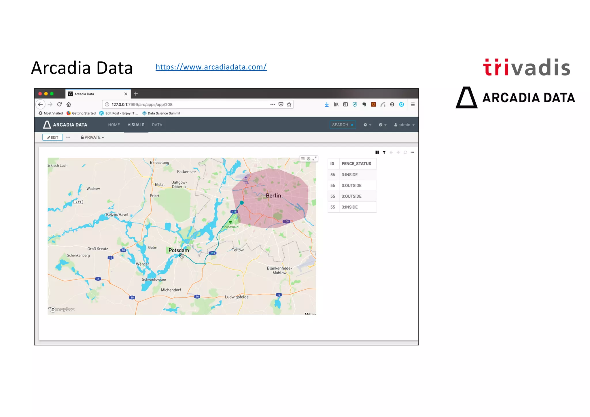
Overview of location analytics, geofencing, and the presentation agenda.
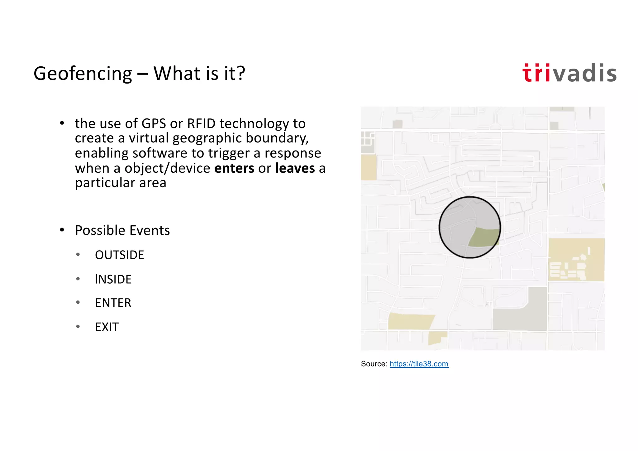
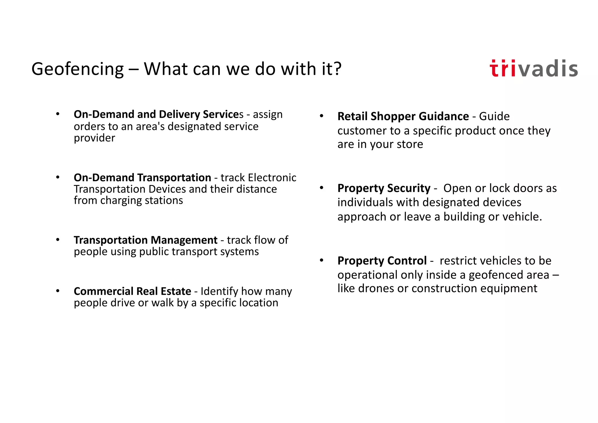
Definition of geofencing; enabling response through GPS/RFID; uses in various sectors like transportation, retail, and security.
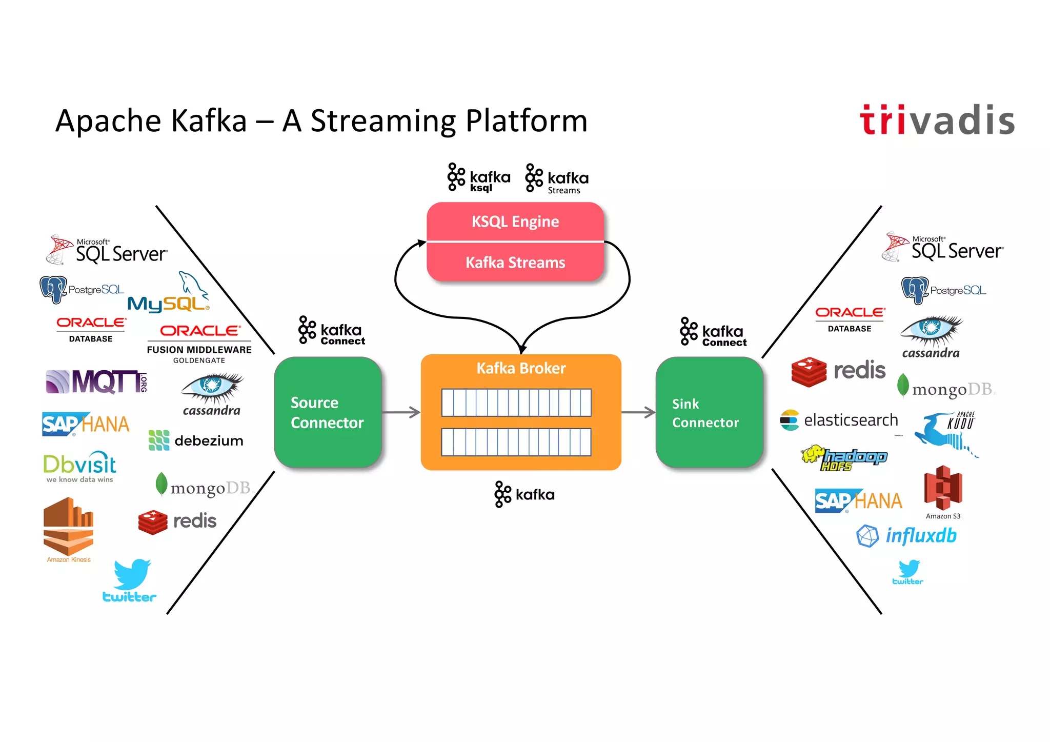
Introduction to Apache Kafka as a streaming platform with components like KSQL Engine, Kafka Streams, and Geo-fencing management.
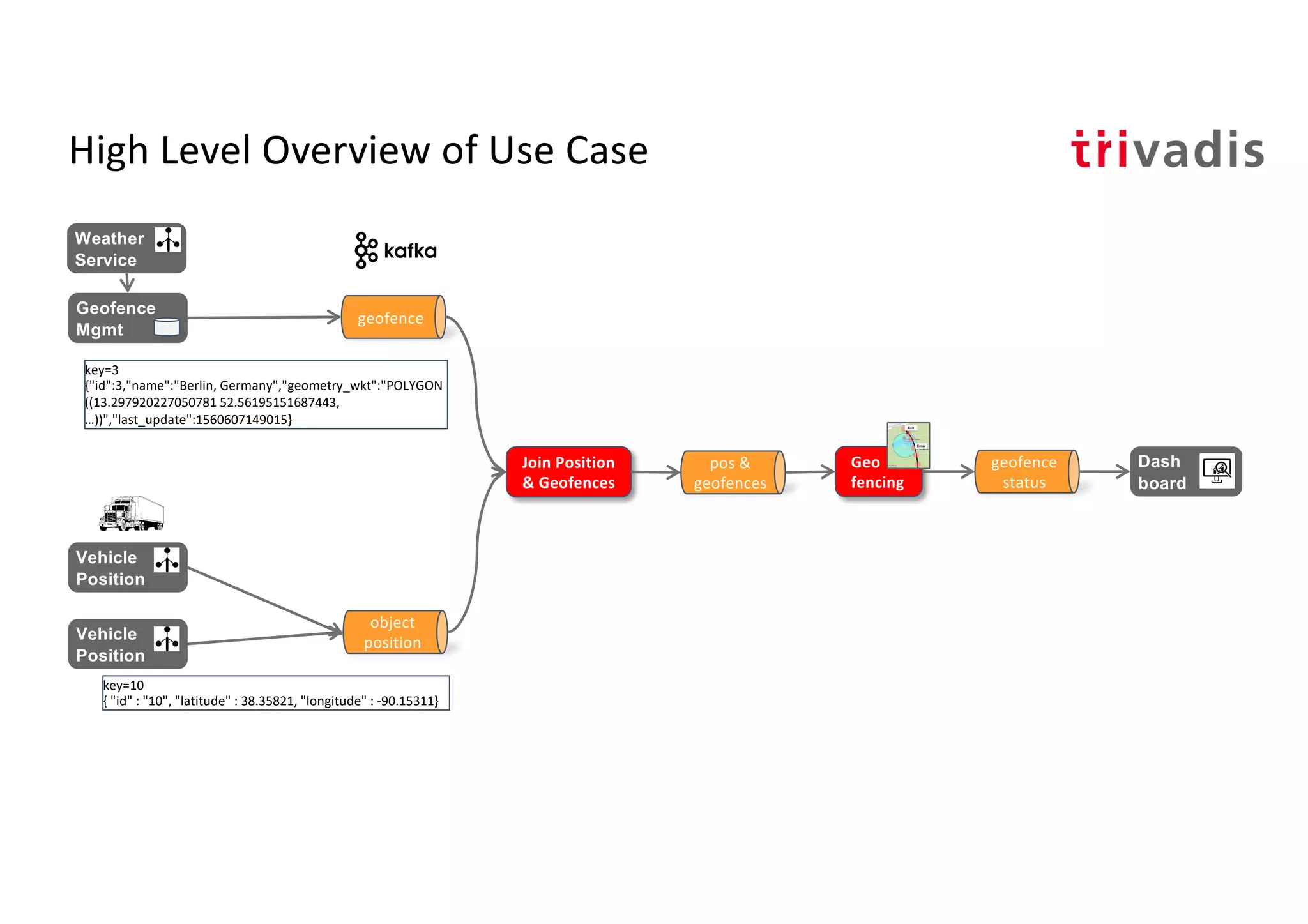
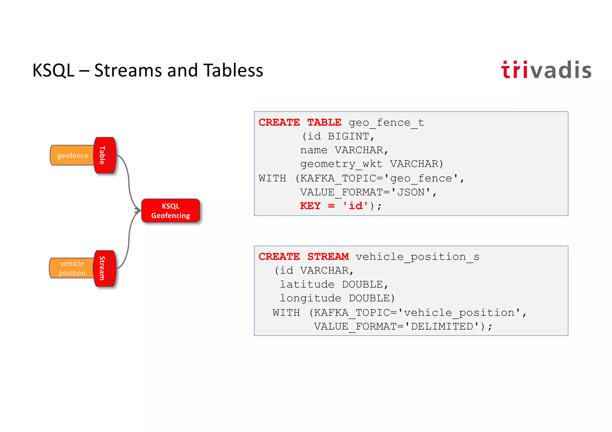
Using KSQL for streaming data and geofencing management, including stream creation and distance calculations.
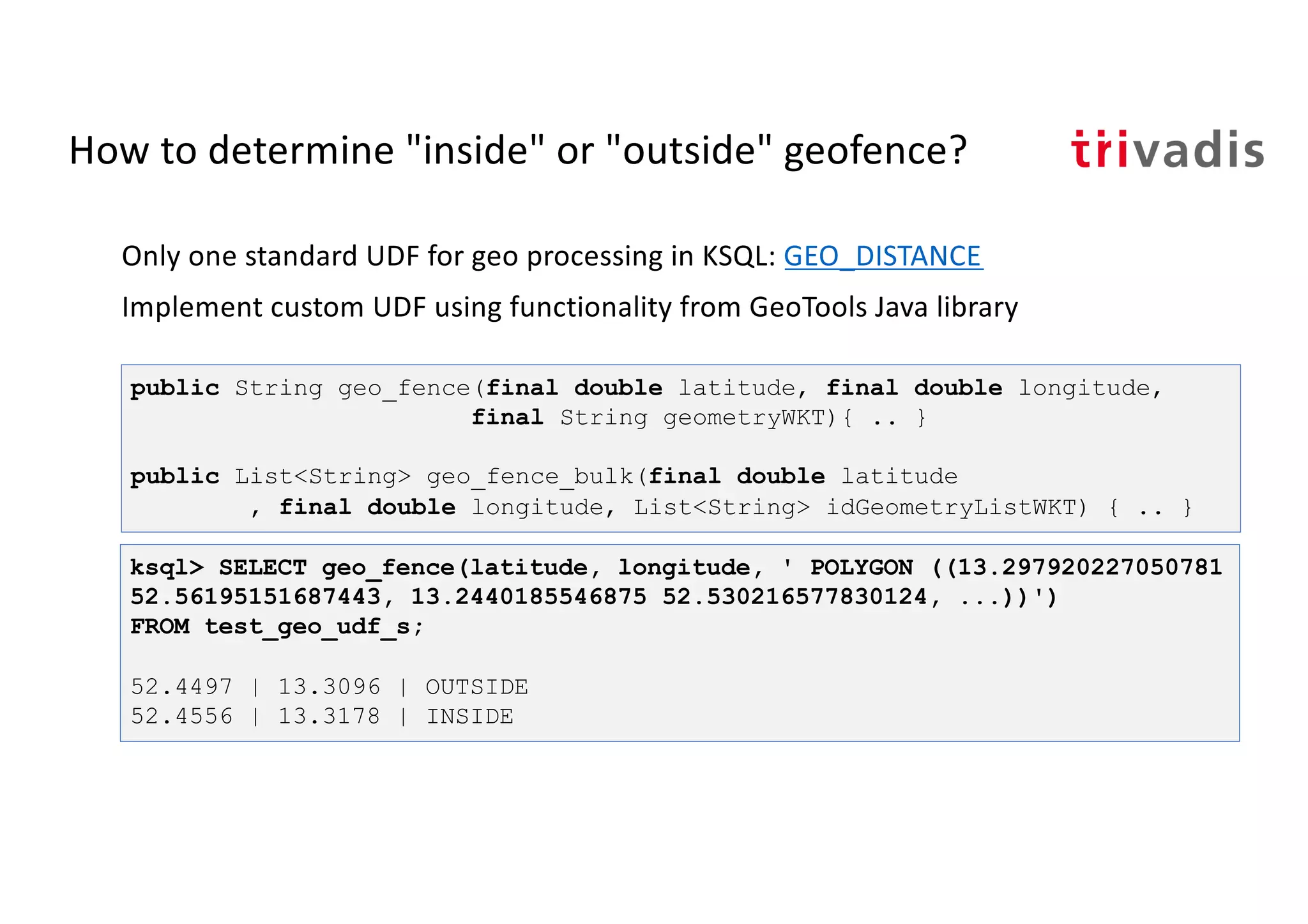
Implementation of custom user-defined functions to check if a point is inside the geometric boundary.
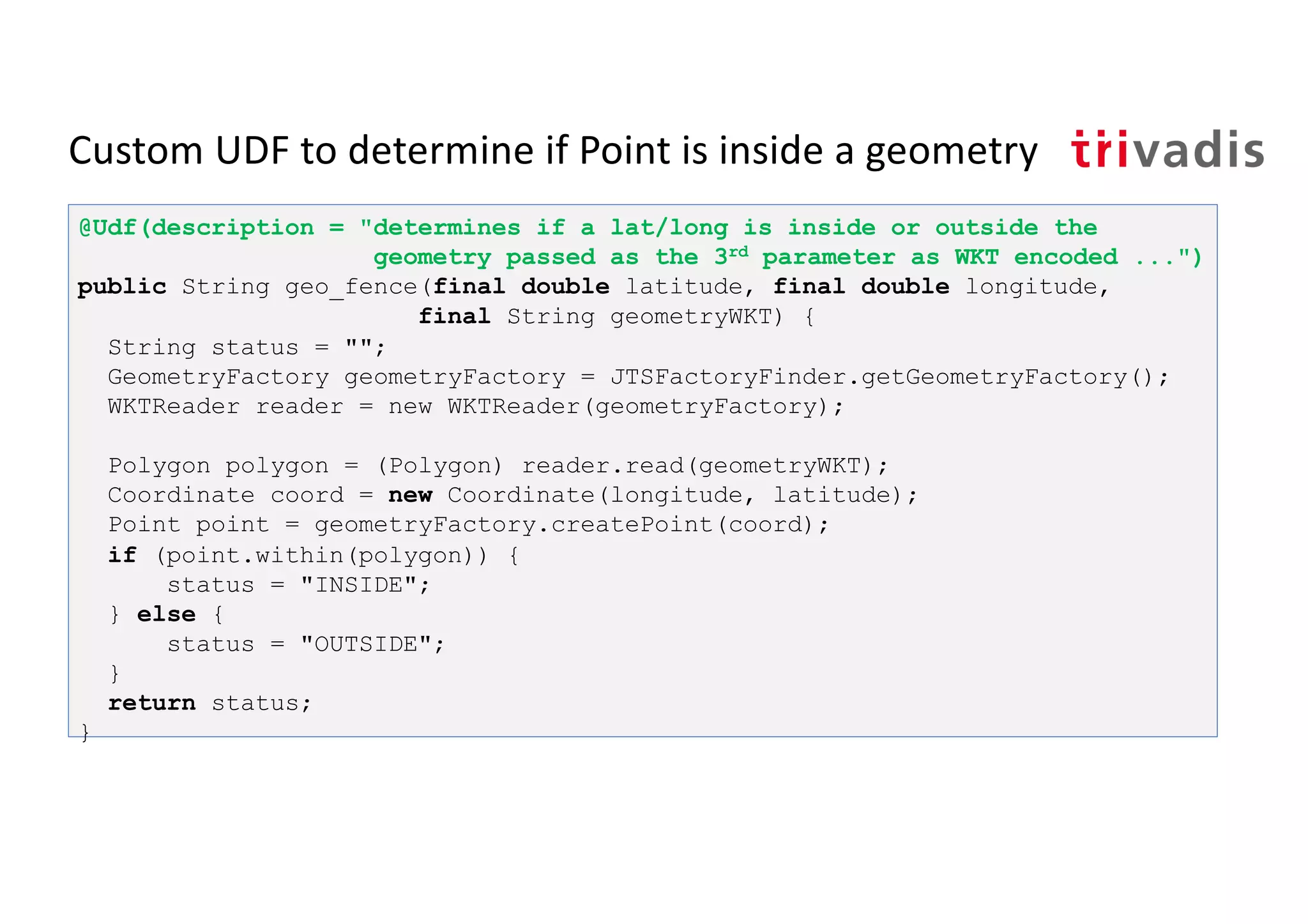
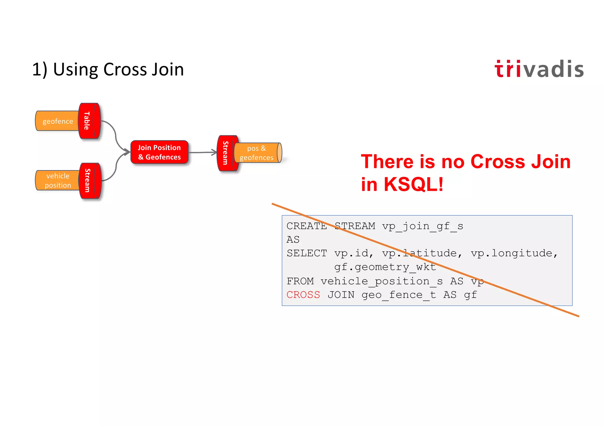
Joining vehicle positions with geofences using CROSS and INNER joins for accurate geofencing analysis.
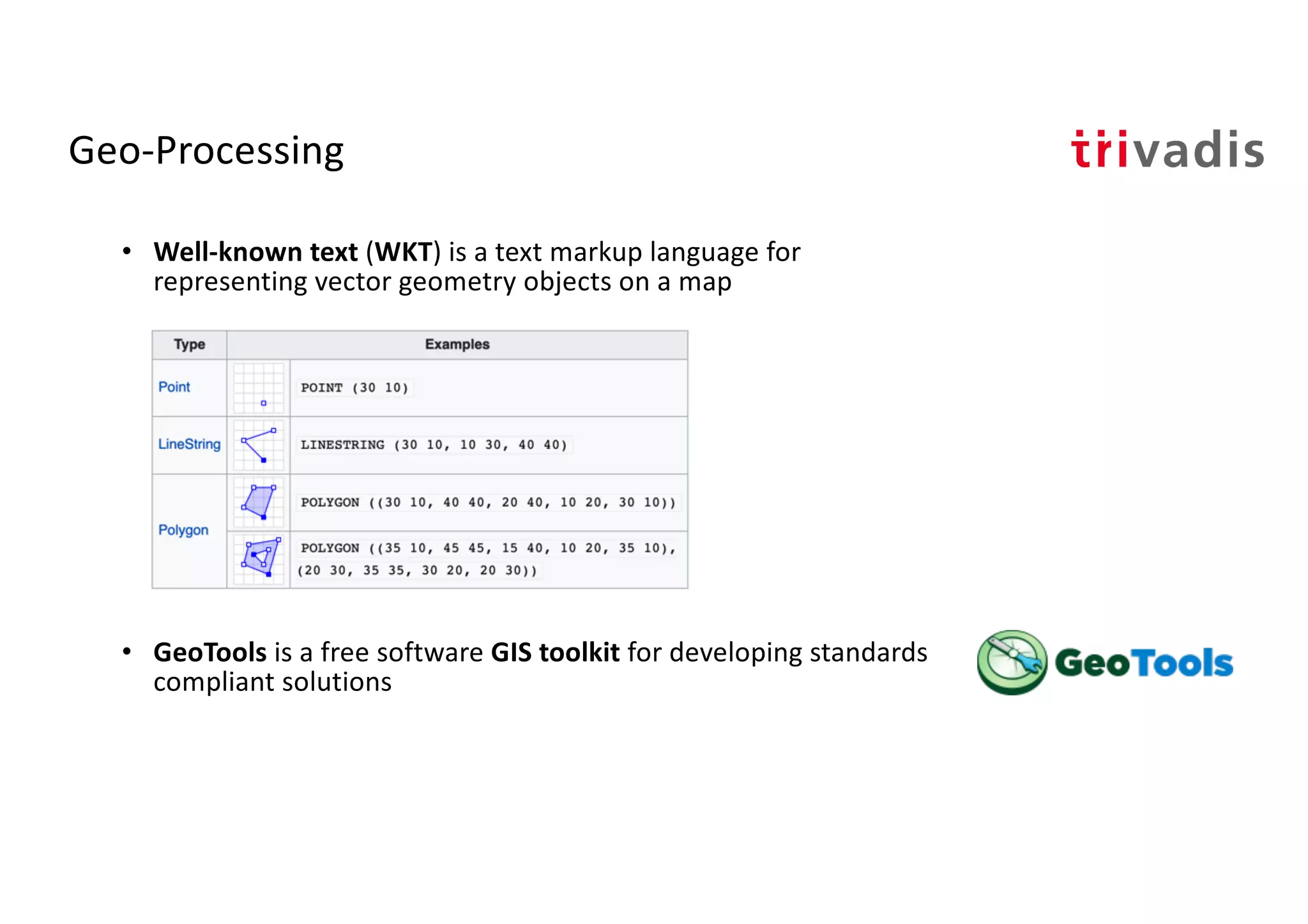
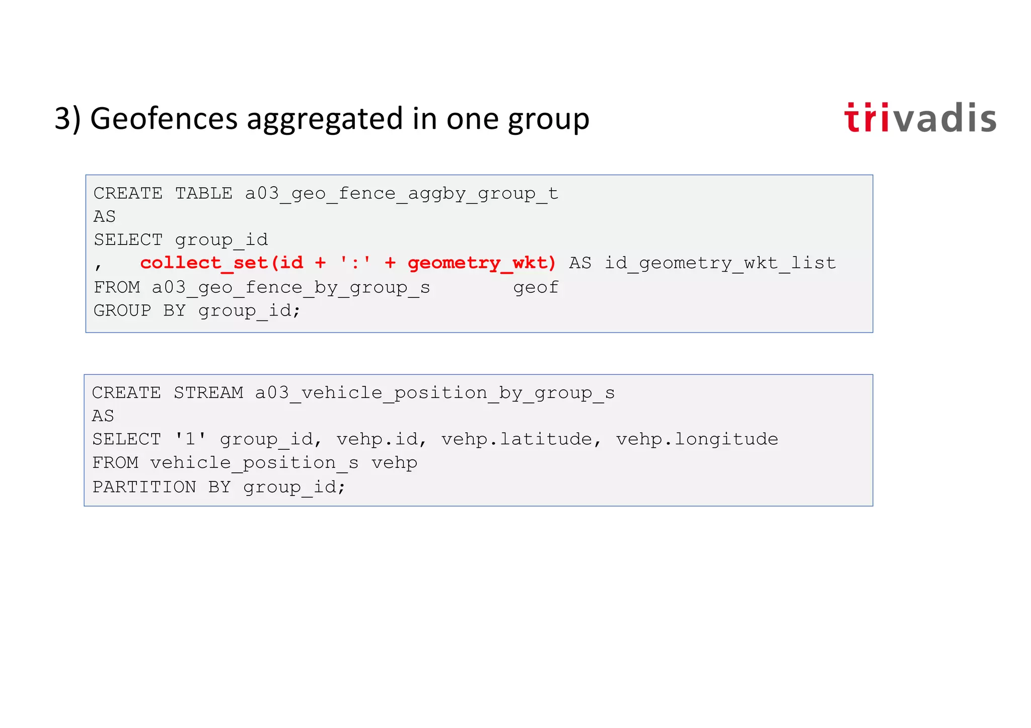
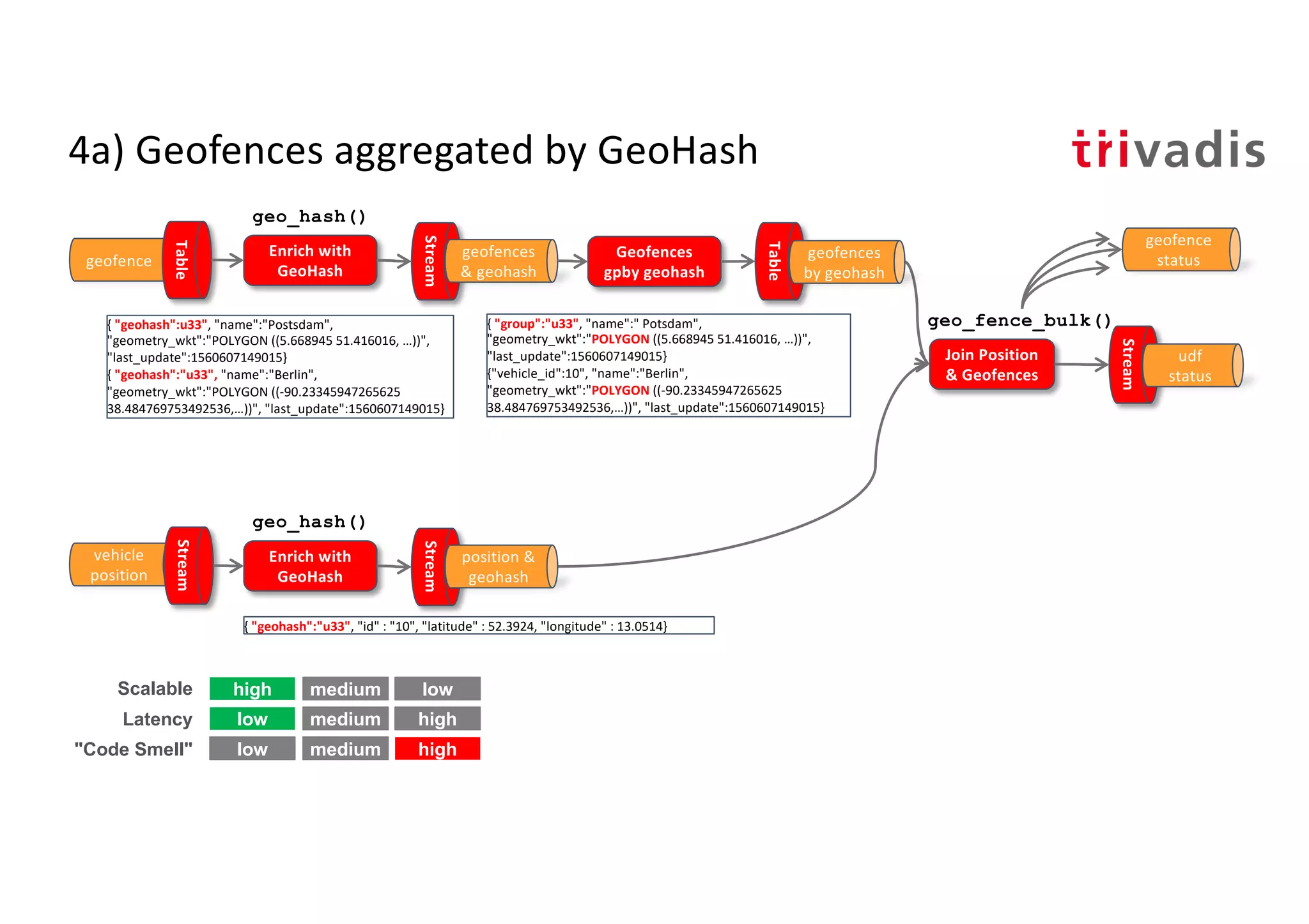
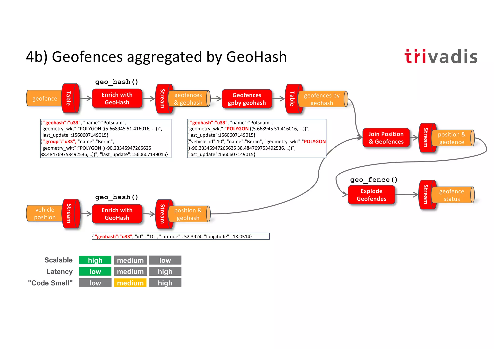
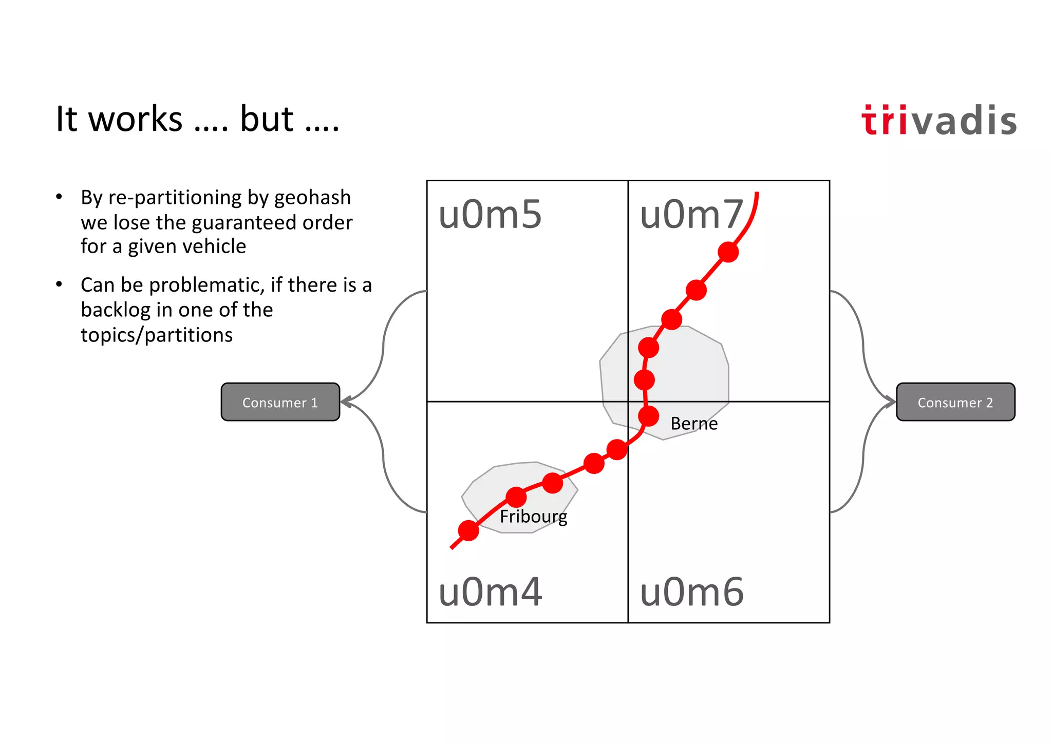
Introduction to geohashing for better spatial data processing and encoding geographical locations.
Aggregation of geofences using geohashing strategies to streamline vehicle geofencing status.
Application of Kafka Streams and Global KTable for enriching vehicle positions with geofencing data.
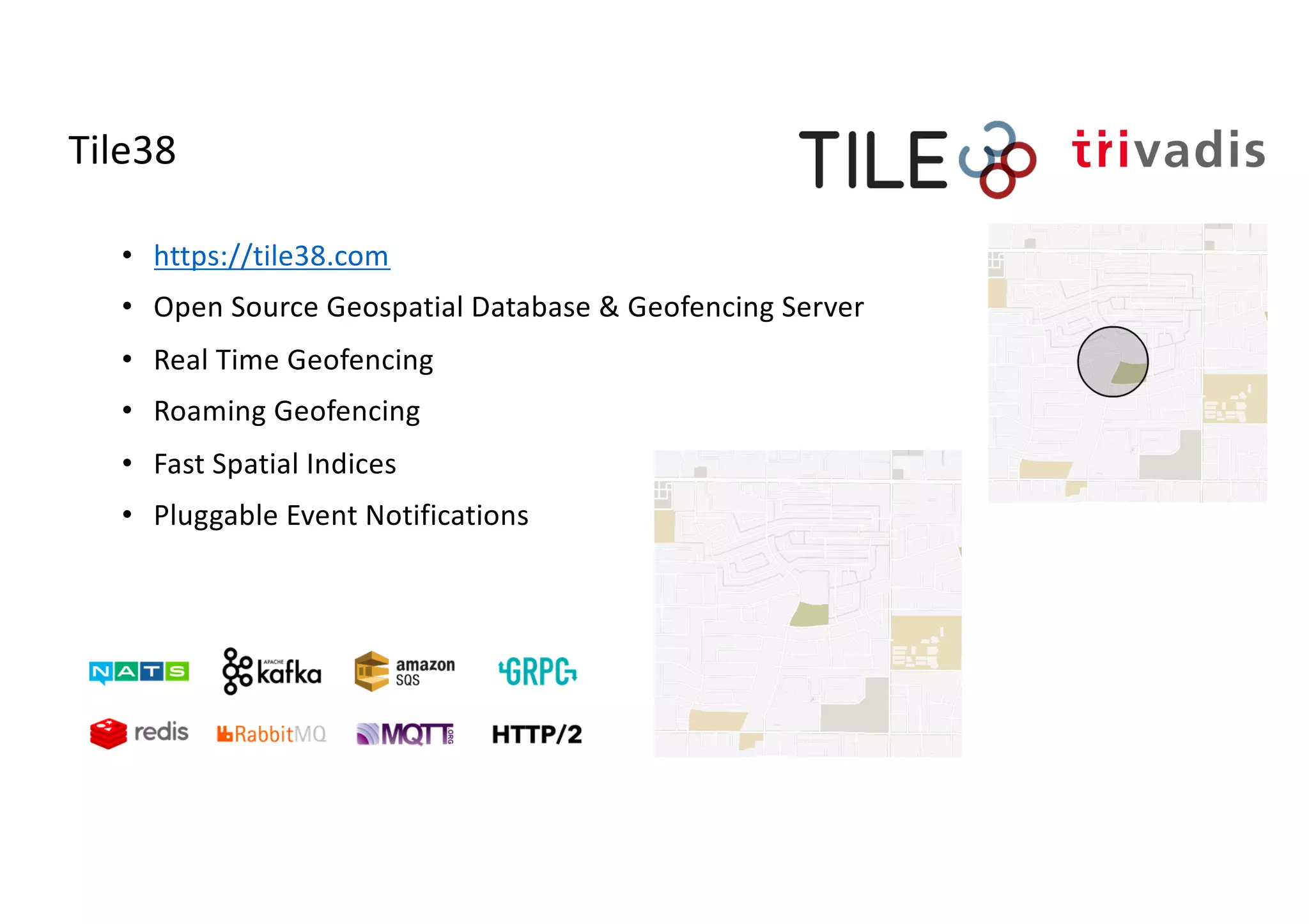
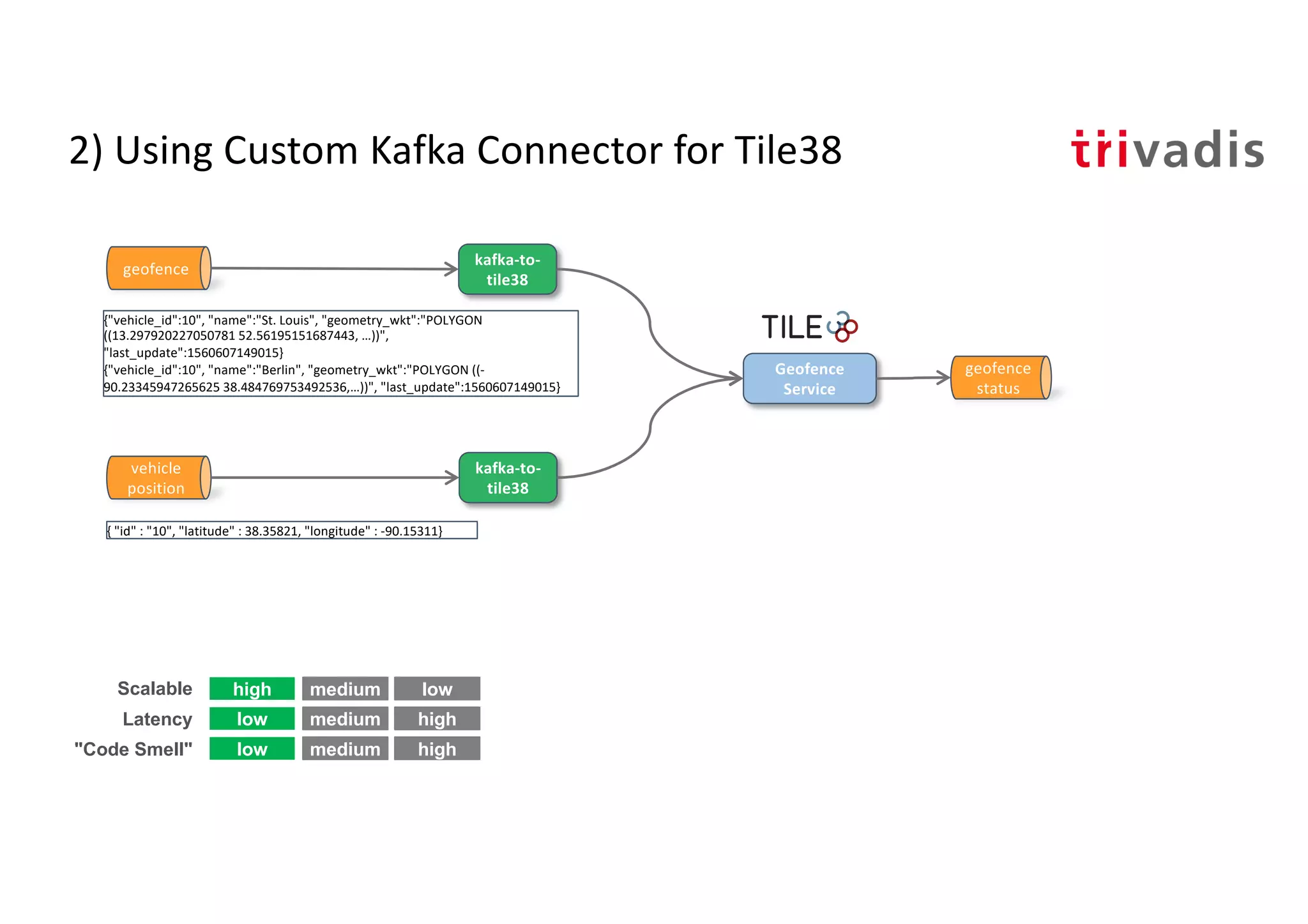
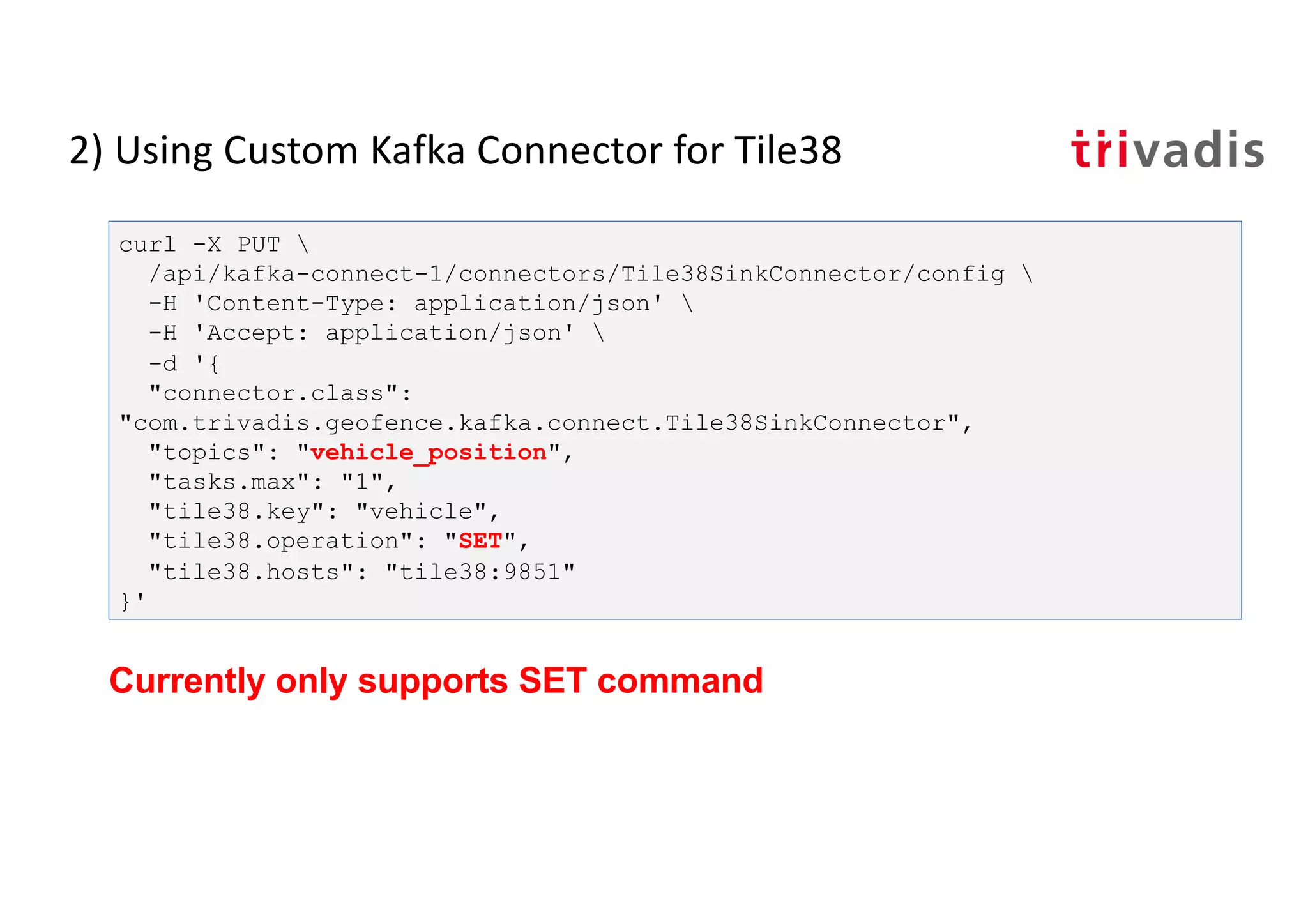
Introduction to Tile38 as a geospatial database for real-time geofencing solutions and its functionalities.
Using Kafka connectors to enrich geofencing status with Tile38 integration for real-time applications.
Overview of visualization tools and presentation summary emphasizing the capabilities of Kafka and KSQL for geofencing.