Downloaded 113 times

![ArcGIS 10.1 for Server Functionality Matrix
J9805
March 2013 4
■ Microsoft Windows Azure® SQL Database
■ Oracle®
■ PostgreSQL
Geodatabase
Management
The geodatabase enables ArcGIS to extend the spatial capabilities of databases to support
the more sophisticated GIS data management workflows and geospatial data models.
Through ArcGIS for Server Basic's geodatabase management capabilities, ArcGIS users
enable multiuser editing from ArcGIS for Desktop as well as geodatabase replication.
Why Use a
Geodatabase
Commercial databases support simple spatial features. Geodatabases build on this
framework and extend the capabilities of your database to ensure that you can enrich your
GIS data models and satisfy the most demanding GIS workflows such as the following:
■ Long transactions and conflict resolution (versioning)
■ Modeling of utility, river, and transportation networks
■ Data validation including topological, attribute, and connectivity rules
■ Tracking of historic transactions
■ Complex features: Annotations (text), dimensions, cadastral fabrics, and so forth
■ Advanced symbology (cartographic representations)
■ Replication across multiple commercial databases in connected and disconnected
environments (geodata services)
The Enterprise level supports multiuser geodatabases on the following relational database
management systems (RDBMS):
■ IBM DB2
■ IBM Informix Dynamic Server
■ Microsoft SQL Server
■ Microsoft SQL Server Express
■ Oracle
■ PostgreSQL
The Workgroup level only supports Microsoft SQL Server Express.
For the most up-to-date information about supported databases, refer to the Database
Requirements section of the ArcGIS Resources site.
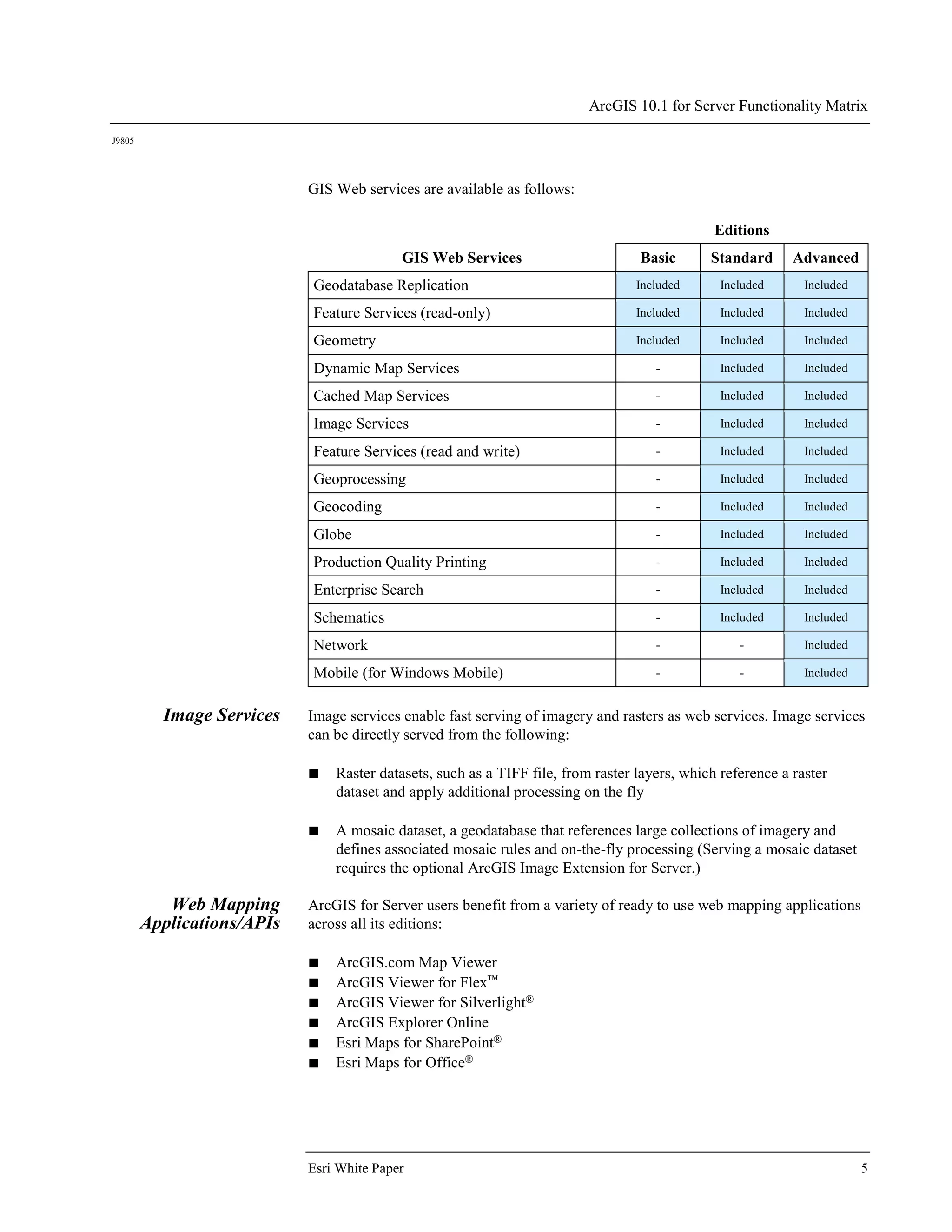
Web Services Web services make it easy to share GIS resources across client applications, including
ArcGIS for Desktop, web mapping applications, mobile devices, and third-party
applications.
What Are GIS Web
Services
GIS web services are used to share resources over a local network or the Internet. ArcGIS
for Server web services conform to web standards (Representational State Transfer
[REST]); industry standards (Simple Object Access Protocol [SOAP]); and Open
Geospatial Consortium, Inc.® (OGC®), standards.](https://image.slidesharecdn.com/arcgis-server-functionality-matrix-130514150532-phpapp02/75/ArcGIS-10-1-for-Server-Functionality-Matrix-7-2048.jpg)


![ArcGIS 10.1 for Server Functionality Matrix
J9805
March 2013 4
■ Microsoft Windows Azure® SQL Database
■ Oracle®
■ PostgreSQL
Geodatabase
Management
The geodatabase enables ArcGIS to extend the spatial capabilities of databases to support
the more sophisticated GIS data management workflows and geospatial data models.
Through ArcGIS for Server Basic's geodatabase management capabilities, ArcGIS users
enable multiuser editing from ArcGIS for Desktop as well as geodatabase replication.
Why Use a
Geodatabase
Commercial databases support simple spatial features. Geodatabases build on this
framework and extend the capabilities of your database to ensure that you can enrich your
GIS data models and satisfy the most demanding GIS workflows such as the following:
■ Long transactions and conflict resolution (versioning)
■ Modeling of utility, river, and transportation networks
■ Data validation including topological, attribute, and connectivity rules
■ Tracking of historic transactions
■ Complex features: Annotations (text), dimensions, cadastral fabrics, and so forth
■ Advanced symbology (cartographic representations)
■ Replication across multiple commercial databases in connected and disconnected
environments (geodata services)
The Enterprise level supports multiuser geodatabases on the following relational database
management systems (RDBMS):
■ IBM DB2
■ IBM Informix Dynamic Server
■ Microsoft SQL Server
■ Microsoft SQL Server Express
■ Oracle
■ PostgreSQL
The Workgroup level only supports Microsoft SQL Server Express.
For the most up-to-date information about supported databases, refer to the Database
Requirements section of the ArcGIS Resources site.
Web Services Web services make it easy to share GIS resources across client applications, including
ArcGIS for Desktop, web mapping applications, mobile devices, and third-party
applications.
What Are GIS Web
Services
GIS web services are used to share resources over a local network or the Internet. ArcGIS
for Server web services conform to web standards (Representational State Transfer
[REST]); industry standards (Simple Object Access Protocol [SOAP]); and Open
Geospatial Consortium, Inc.® (OGC®), standards.](https://crownmelresort.com/image.slidesharecdn.com/arcgis-server-functionality-matrix-130514150532-phpapp02/75/ArcGIS-10-1-for-Server-Functionality-Matrix-7-2048.jpg)


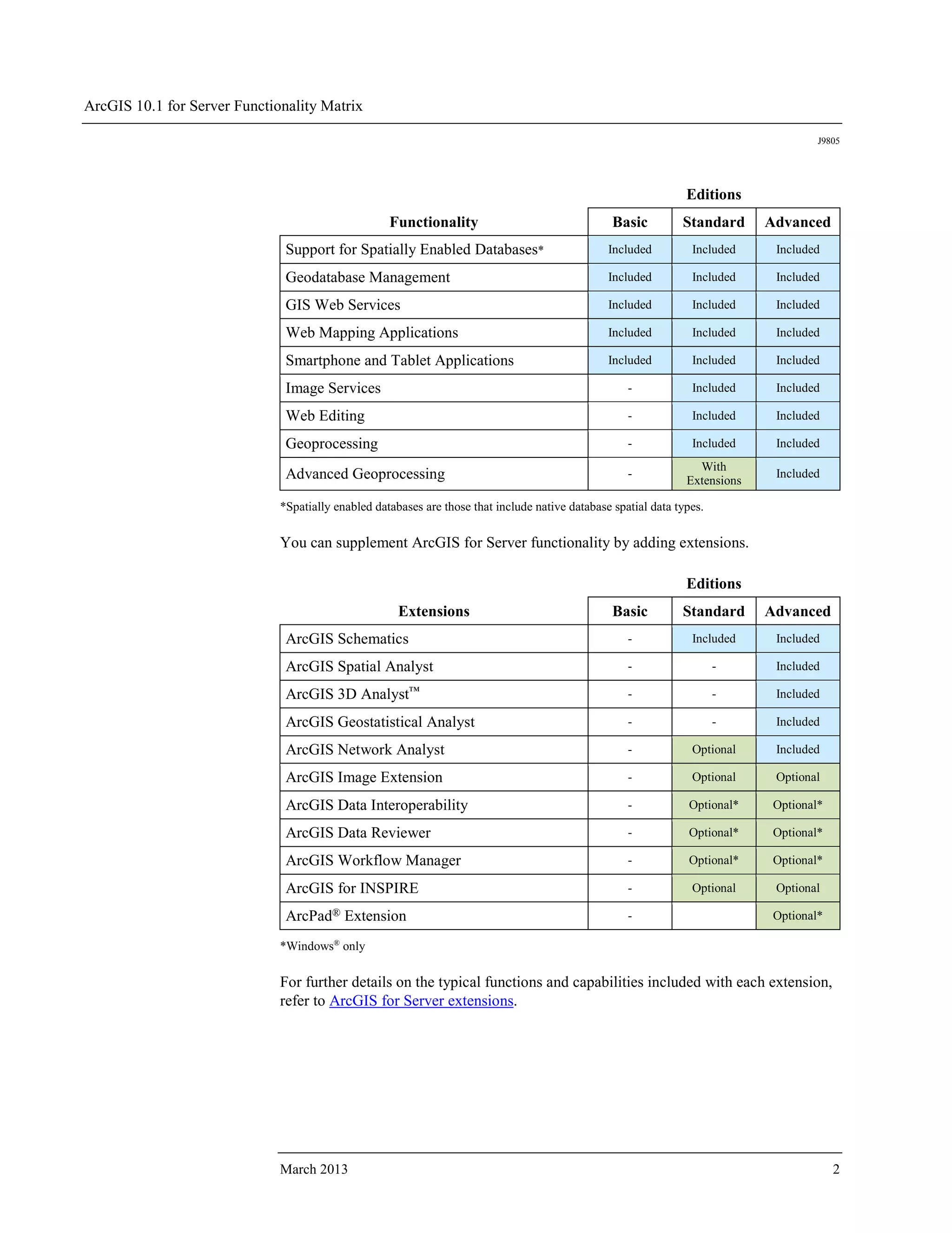
This document provides a functionality matrix to help select the appropriate edition and level of ArcGIS for Server. It describes the core functionality included in each edition such as support for spatially enabled databases, web services, and geoprocessing. It also provides examples of how different editions may be used in scenarios like supporting a large city government with advanced analysis, extensive data, and internal and public applications. The Enterprise Advanced edition is recommended for large organizations with many users and petabytes of imagery requiring advanced analysis.